Michigan’s concern for a potential winter underwater pipeline spill in the Straits of Mackinac – and preliminary research behind a developing strategy for what might be done to clear oil from beneath icy waters – was addressed at April’s upcoming IPPSR Public Policy Forum.
The April 17 Public Policy Forum reported on public perceptions of the risks of underwater oil spills based on surveys and 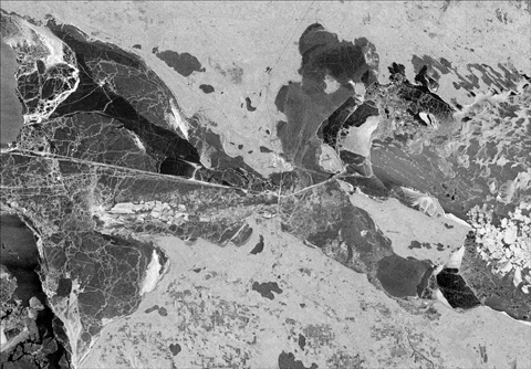 modeling conducted with the support of a Michigan Applied Public Policy Research (MAPPR) grant.
Michigan State University’s Institute for Public Policy and Social Research (IPPSR) awarded the grant to four faculty members from MSU Colleges of Agriculture and Natural Resources and Engineering.
The researchers presented preliminary findings from the first-time investigation into how oil accumulates and spreads beneath lake ice during the winter season. Great Lakes tourism and area employment will be considered in the discussion. Insights into the level of citizen awareness of the transport of light crude oil and liquid natural gas being transported between Michigan’s two peninsulas will be presented.
IPPSR Public Policy Forum panelists were:
· Doug Bessette, assistant professor, Community Sustainability, College of Agriculture and Natural Resources
· Volodymyr (Vlad) Tarabara, professor, Department of Civil and Environmental Engineering in MSU’s College of Engineering
· Robert Richardson, associate professor and ecological economist, College of Agriculture and Natural Resources.
IPPSR is a unit of MSU’s College of Social Science. It is the home of the Michigan Political Leadership Program, the Office for Survey Research, the State of the State Survey and the State of the State Podcast.
Videos, presentations and photos from past IPPSR Forums can be viewed at ippsr.msu.edu. The next forum is set for May 8, 2019.
The image above is a radar image of the Straits of Mackinac. Taken on February 9, 2019, it shows the region entirely ice covered, with variations in light and dark tones representing variations in ice types, roughness, and cracks/leads of ice pans. This type of imagery will be used in analysis of the potential to observe and track oil spills using remotely sensed observations.